

How to learn country shapes
Why some outlines stick at first sight, how to place the ones that don't, and the country pairs almost everyone mixes up.
Updated Facts checked
On this page6 sections
The quickest way to learn country shapes is to start with the outlines you won't forget, learn one region at a time, and use each country's neighbors and coastline as anchors. Once a region feels familiar, test yourself on the outlines alone, with no map around them. A few minutes a day over several days works better than one long session. And quizzing yourself works better than staring at a map alone.
Why are some country shapes easier to remember?
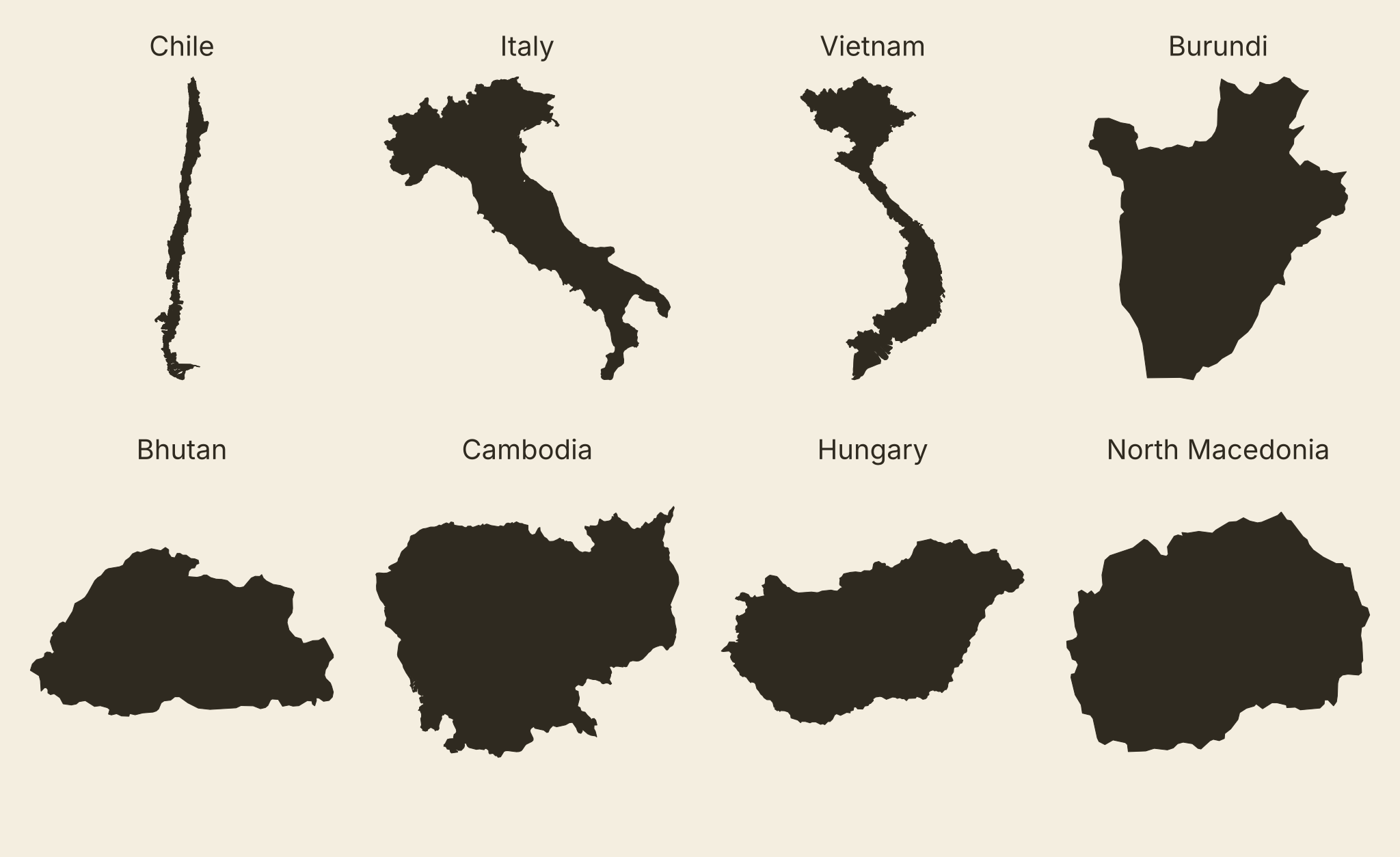
It comes down to whether the outline has any distinguishable features. Those are the countries to learn first, because they become the landmarks you place everything else around. Chile is the standard example. It runs about 4,300 km (2,700 miles) from north to south, but on average it's only about 180 km (110 miles) wide. On a map that's a thin ribbon down the west side of South America. Once you've seen it, you won't confuse it with anything else.
Italy's boot works the same way. So does Vietnam, a long S that stretches 1,650 km (1,025 miles) north to south and pinches to about 50 km (31 miles) across at its narrowest point. Size doesn't decide it. Burundi is small, about 27,800 square km, but its outline, broad at the top and tapering to a point at the bottom like a shield, is one of the easiest on the continent to spot.
The hard ones are the outlines with nothing to grab. Bhutan, Hungary and North Macedonia are each a rounded, slightly lumpy shape with no point, tail or inlet you could describe to someone over the phone. Cambodia comes close, though its outline has a little more to grab. You'll learn these by where they sit, not by how they look.
Learn country shapes by region, not alphabetically
An alphabetical list is the slowest way to do this, because a shape sticks far better when you know what sits next to it. The list puts Bolivia between Bhutan and Bosnia and Herzegovina, which tells you nothing. A map of South America puts it in the middle of the continent with no coastline, touching Argentina, Brazil, Chile, Paraguay and Peru. That's something you can hold on to.
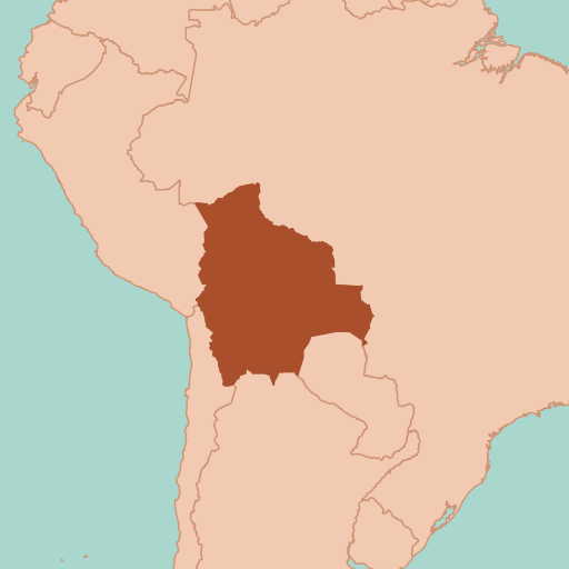
South America is the place to start, because it comes with two anchors you probably already know. Brazil is the largest country on the continent and borders every other South American country except Chile and Ecuador. Chile runs down the Pacific side. Get those two in place and you'll notice the rest falling into the gaps between them.
Africa comes next. It's a bigger job, but the coastline gives you a frame: learn the countries around the edge first, then fill in the landlocked ones in the middle. Europe is where most people slow down. France, Spain and Italy come easily. The Balkans don't, because they pack small countries close together, and some of them, like North Macedonia, have no feature to hold on to. Give that corner of the map its own sessions, and learn it as a cluster of neighbors.
World Tour in MapFiend is built for this stage. Each round highlights one country's outline on the map with the surrounding region visible, and you pick the name from four options. There's no clock and you have three lives, so you can take your time looking at the neighbors before you answer.
Use neighbors and coastlines as anchors
When a shape on its own means nothing to you, look at what's around it and whether it touches the sea. That usually gives it away.
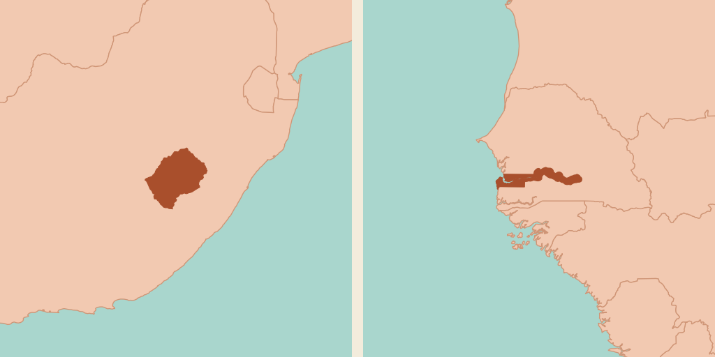
A few countries are almost entirely defined by one neighbor. Lesotho is landlocked and completely surrounded by South Africa. Its own outline is a plain rounded shape, but once you know South Africa, you'll see it as the hole inside. The Gambia is a thin strip that follows the Gambia River inland from the Atlantic. Senegal wraps around it on every side except its 80 km (50 miles) of coast. It's the smallest country on the African mainland, and the easy way to find it is to find Senegal first.
The coast is the other quick check. Laos is the only landlocked country in Southeast Asia, so if a mainland Southeast Asian shape doesn't touch the sea, it's Laos. And its outline helps too: a wide top with a long, narrow tail running southeast. Its neighbors are Myanmar, Cambodia, China, Thailand and Vietnam, and saying them out loud while you look at the map helps the shape stick to its place.
Central Asia works the same way: place one or two anchors and the rest fall into line. Afghanistan has a long, thin panhandle in the northeast, the Wakhan Corridor, and it separates Tajikistan to the north from Pakistan to the south. Turkmenistan is much wider than it is tall, like its near-namesake Türkiye. Once those are in place, Uzbekistan and Kyrgyzstan are easy to tell apart, because their outlines look nothing alike.
Which countries are easiest to mix up?
Most mix-ups come in two kinds: names that sound almost the same, and silhouettes that look alike once the map around them is gone. Either way, you don't need to memorize both outlines in detail. Learn one clear difference and lean on that.
| Countries | Why they get mixed up | The difference to remember |
|---|---|---|
| Slovenia and Slovakia | Name | Slovenia has a short coast on the Adriatic, 46.6 km (29 miles), and borders Italy. Slovakia is landlocked, south of Poland. |
| Paraguay and Uruguay | Name | Paraguay is landlocked between Argentina, Bolivia and Brazil. Uruguay sits on the Atlantic coast between Argentina and Brazil. |
| Niger and Nigeria | Name, and they share a border | Niger is landlocked and the bigger of the two. Nigeria has the coast, on the Gulf of Guinea. |
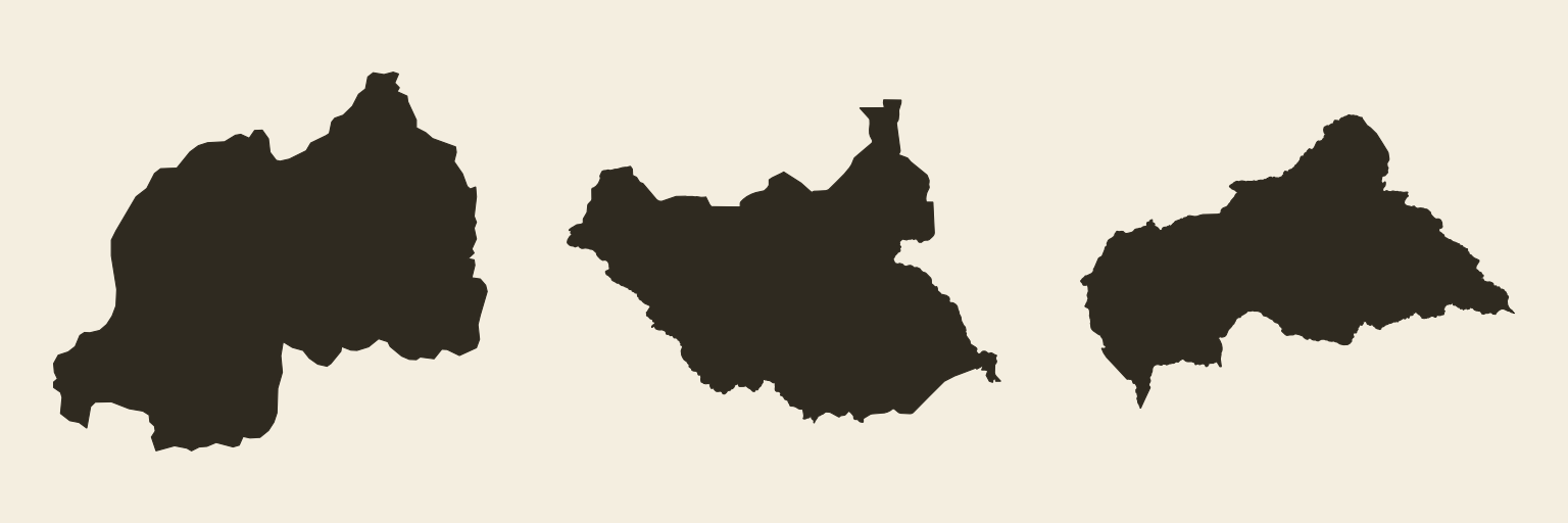
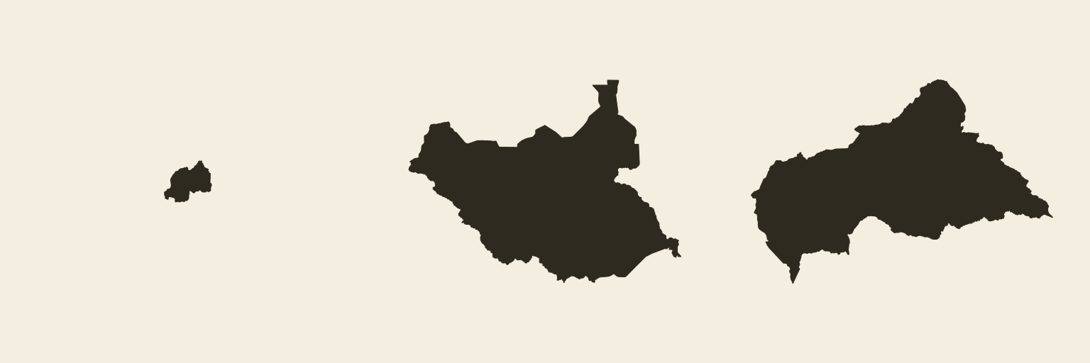
| Rwanda, South Sudan and the Central African Republic | Silhouette | Each is a compact body with a bump rising on the northeast side. Rwanda is the tiny one, about 26,300 square km against more than 600,000 for each of the others. |
Two memory tricks help with the name pairs. Slovakia was one half of Czechoslovakia until the country split in 1993, and it was never "Czechoslovenia", so Slovakia is the one next to Czechia. And Uruguay is the one further down the map, under Paraguay.
That last row shows something worth knowing about lone outlines. Drawn on its own, at whatever size fits the screen, a shape loses its scale. Rwanda and South Sudan look like cousins as silhouettes. On a map of Africa, South Sudan is more than 20 times bigger, and you'd never mix them up.
How to practice so the shapes stick
Short, regular sessions where you test yourself beat long sessions spent looking at a map. A 2013 review of common study techniques, published by the Association for Psychological Science, rated two methods highest: practice testing and spreading study out over time. Rereading and highlighting were rated low. For country shapes, that means guessing first and checking after, a few minutes a day, every day.
Once you can name a region's countries with the neighbors visible, take the neighbors away. If you can only name Paraguay when Brazil is sitting next to it, you haven't quite got it yet. In MapFiend, Quick Play does this directly: on Medium and Hard you get the outline alone, with no region around it, eight countries a run. Gauntlet gets you there in steps: its early stations show the region, and after that the outlines stand alone.
For the daily part, a fixed set of countries once a day works well. That's how the Daily in MapFiend works: everyone gets the same set of countries, and you get one go at it. A new set arrives at midnight, and playing every day builds your Daily streak. That's self-testing spread across days, the pattern the 2013 review favored. You can play the Daily any time before the next set arrives.
To put all of this to work, start in World Tour, where the region stays visible while you learn, and move to Quick Play or Gauntlet once a region feels solid. The how to play page has the rules for every mode.
Sources
(25)ShowHide
- 1Chile (print article)Encyclopaedia Britannica
- 2ChileBritannica Kids (Student)
- 3Vietnam, Geography noteCIA World Factbook (final edition)
- 4Brazil, Geography noteCIA World Factbook (final edition)
- 5Chile, Location / Land boundariesCIA World Factbook (final edition)
- 6Bolivia, Land boundaries / CoastlineCIA World Factbook (final edition)
- 7Lesotho, Location / Geography noteCIA World Factbook (final edition)
- 8LesothoEncyclopaedia Britannica
- 9The Gambia, Land boundaries / Coastline / Geography noteCIA World Factbook (final edition)
- 10The GambiaEncyclopaedia Britannica
- 11LaosNational Geographic Kids
- 12Laos, Land boundaries / CoastlineCIA World Factbook (final edition)
- 13Slovenia, Land boundaries / CoastlineCIA World Factbook (final edition)
- 14Slovakia, Location / Land boundaries / CoastlineCIA World Factbook (final edition)
- 15Paraguay, Geography noteCIA World Factbook (final edition)
- 16Uruguay, Location / CoastlineCIA World Factbook (final edition)
- 17Psychological Science in the Public InterestAssociation for Psychological Science press release on Dunlosky et al. (2013)
- 18Rwanda / South Sudan / Central African Republic, AreaCIA World Factbook (final edition)
- 19Rwanda / South Sudan / Central African Republic, AreaCIA World Factbook (final edition)
- 20Rwanda / South Sudan / Central African Republic, AreaCIA World Factbook (final edition)
- 21Burundi, AreaCIA World Factbook (final edition)
- 22Niger and Nigeria, Location / Area / Land boundaries / CoastlineCIA World Factbook (final edition)
- 23Niger and Nigeria, Location / Area / Land boundaries / CoastlineCIA World Factbook (final edition)
- 24WakhanEncyclopaedia Britannica
- 25CzechoslovakiaEncyclopaedia Britannica

Relaxed · 3 Lives187 Countries · Relaxed · 3 Lives
Start with World Tour
Three lives, no clock, and the region in view while you learn the shapes.
Country shapes FAQ
Can you guess a country by its shape?
Yes, for most countries, once you've learned them with their neighbors. Outlines with one clear feature, like Chile, Italy, Vietnam and Burundi, are the easiest. Featureless shapes such as Hungary or Bhutan are usually recognized by where they sit, not by their outline.
What are the easiest country shapes to learn?
Long, thin or oddly shaped countries. Chile (about 4,300 km long and about 180 km wide on average), Italy's boot and Vietnam's long S are the usual first wins.
What's the best way to memorize all the countries of the world?
Learn one region at a time instead of alphabetically, starting with South America, then Africa, then Europe and Asia. Use neighbors and coastlines as anchors, and test yourself in short daily sessions instead of rereading a map.
How do I stop mixing up similar countries?
Pick one difference per pair and drill that. Slovenia has a coast and Slovakia doesn't. Paraguay is landlocked and Uruguay isn't. Niger is landlocked and Nigeria isn't. For look-alike silhouettes such as Rwanda and South Sudan, remember the size: Rwanda is tiny.
Is there a game to learn country shapes?
Several. Worldle gives you one country silhouette a day, and quiz sites like Seterra and JetPunk test where countries are on the map. MapFiend is built around recognizing each country from its outline, with modes that show the surrounding region while you learn and modes that show the outline alone when you want a harder test.